The Stormy Conditions Continue…
1st February 2024
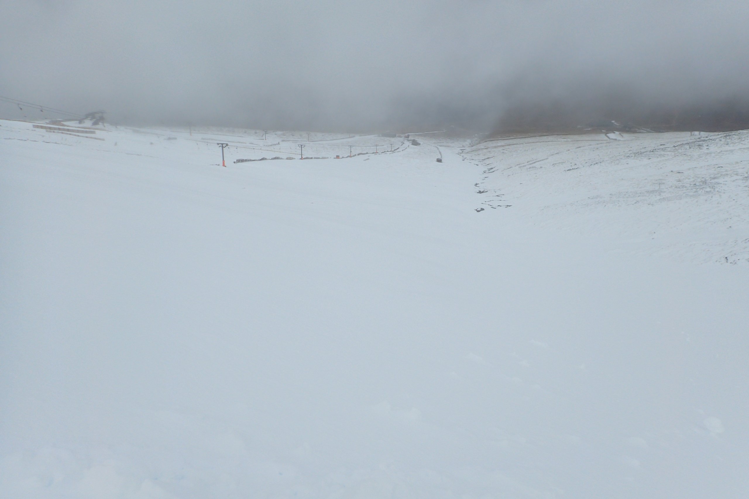
It was a cloudy, claggy day on Aonach Mor, with poor visibility. There had been more snow overnight than expected. I could not see if there had been any avalanche activity in Coire an Lochan, but it would not surprise me if there had been. Some avalanche activity did occur on Ben Nevis. Turning mild this evening, before cooler at the weekend. The meteorological rollercoaster ride continues…
Looking down the Goose Gully during one the periods of better visibility. There was a reasonable amount of fresh snow at higher levels.

Looking down Easy Gully in poor visibility.

The Aonach Mor summit plateau is very icy from the precipitation and temperature fluctuations of late.

Looking up towards the Orion face area on Ben Nevis. Some fresh debris can be seen in the bowl below Zero gully.
I thought it might be interesting to have a look at the weather over the past month or so, and how it has compared to other seasons.

The midday Aonach Mor air temperature this season as compared to the maximum, minimum and average from the season 2007/08 to now.
This season the data starts on the 22nd of December as before that there was no snow, and we were not not recording the information. On three days; 23rd of December, the 12th and 27th of January the temperature this year was the highest recorded on that date. In fact the 8.3C on the 27th of Jan this year is the equal highest January temperature in this dataset (the 24th of January 2023 middy temperature was also 8.3C).
The midday temperature on the 15th, 17th and 18th of January were the lowest values recorded on those dates (in fact the -9.2 and -9.6 recorded the first two of those days are the two lowest January temperatures I have on this dataset).
Interesting that the warmest (equal) and coldest January midday temperatures in 17 years, were both this year and were only 10 days apart.

The midday summit temperature anomaly.
For the 40 days from the 22nd of Dec until the 31st of January inclusive (but excluding the 27th of Dec when the data is missing) there were 21 days when the midday temperature was above the average for that date, and 19 days where it was below. There are a few days when it looks like the data is missing (9th and 21st of Jan), but in fact they are just very close to average.

The average January summit midday temperature since 2008.
This year the average temperature was -2.0C. Of the previous 16 Januarys, 9 were colder and 7 were warmer, so in terms of average temperature nothing unusual. However, average temperature might not be the most representative measure of how wintery it has felt, perhaps the percentage of days above freezing on the summit might be a better measure of this.

The average 24 hour wind speed from the met office weather station on the summit of Aonach Mor.
One notable thing is how windy the last ten days or so of January were. For the seven days leading up to and including the 28th of January, the mean wind was 45.0 knots. That is the 3rd windiest 7 day period in the dataset of the last 17 winters. The other two periods were the 7 days up to the 15th Jan 2015 (46.7 knots) and up to the 27th Dec 2016 (45.4 knots). It is worth noting that some of the wind data up to about 2010 is missing, so there could have been windier periods then which I missed.
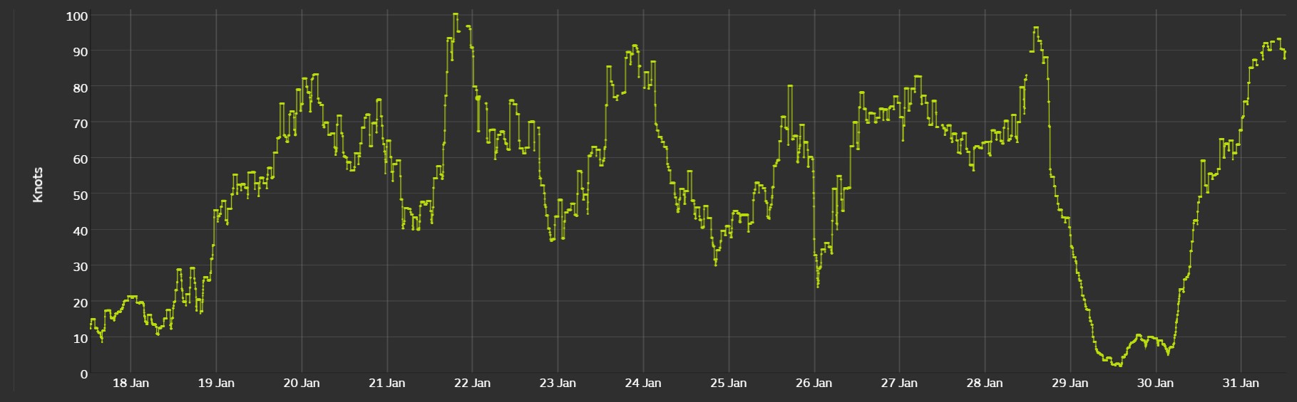
The maximum gust recorded every hour on the Met office weather station on Aonach Mor for the 18th to the 31st of January.
From the 19th until the 31st of January(with the exception of the 29th) it has been consistently windy. On the Beaufort scale (which admittedly was designed for use on the sea rather than in the mountains) 64 knots corresponds to hurricane force. The wind has been gusting that speed most days, and there have been six or seven periods when it has gusted 80 knots or more.
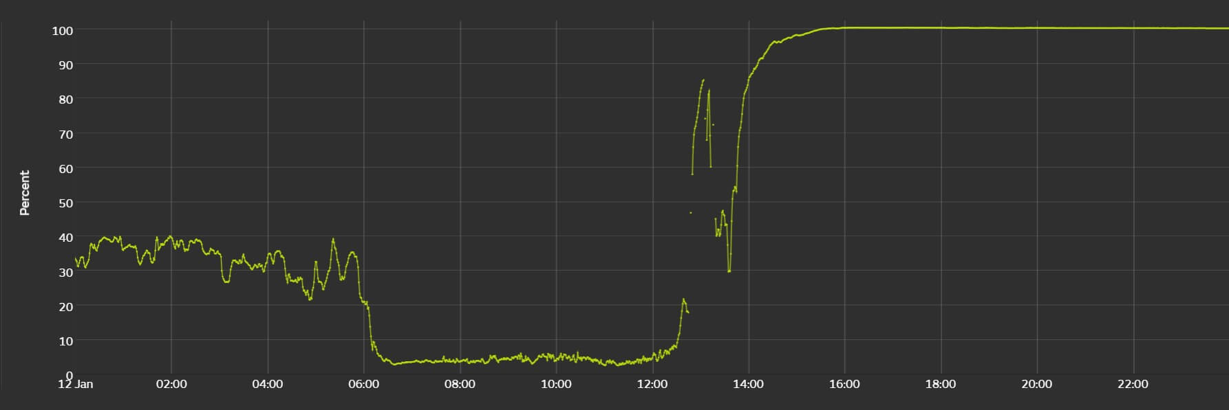
There was a period of unusually low relative humidity in the middle of the month.
On the 12th the humidity dropped to around 4% for about 6 hours, with a minimum value of about 2.6%. I am not sure how accurate this is, but is is not unprecedented for mountain stations to see unusually low values (by comparison, and I have to admit I am not 100% sure of this but as far as I know the lowest relative humidity recorded by a low level station was at RAF Honington in Suffolk at 1400 GMT on 30 June 1976 when the humidity fell to 8%). There is a BBC article about how very dry air is occasionally found on the tops of the Lochaber hills here
Comments on this post
Got something to say? Leave a comment