Lapse Rates
13th January 2023
It was a cloudy claggy day on Aonach Mor today. Visibility was poor. Lots of snow at higher levels over the past few days but due to relatively mild conditions (freezing level around 900 metres) there is little below about 700 metres. Some cornices starting to form at higher levels.

Poor visibility at all levels of the hill today. I think picture from 1200 metres sums up conditions.
Thanks for the comments about the weather stations post I did a couple of days ago. The first thing to note is that there is another holfuy weather station on Aonach Mor, the data from it is here https://holfuy.com/en/weather/657 It’s name is the not very descriptive 657, but I refer to it as the intake (as it is at the intake for the hydro-scheme). It does not measure wind, is at a relatively low altitude (550m) which means I don’t find it as useful as some of the ones further up the hill. It does have a webcam, measure light levels, which is quite interesting but not too relevant, and rainfall. However, the rainfall measurement seems a bit broken.
Anyway Mark Figiel’s comment on that post about lapse rate got me thinking, this is something I could have a look into as I can access data from a number of weather stations at different known altitudes. Below is a graph of temperature every hour for 48 hours from 6am on Wednesday morning. As would be expected, in general the higher up the hill the colder, and larger scale trends (the warming on Wed evening for example) is common to all. Interestingly it was warmer at T17 on Thursday morning, than at the intake. I am not sure what would have caused that.
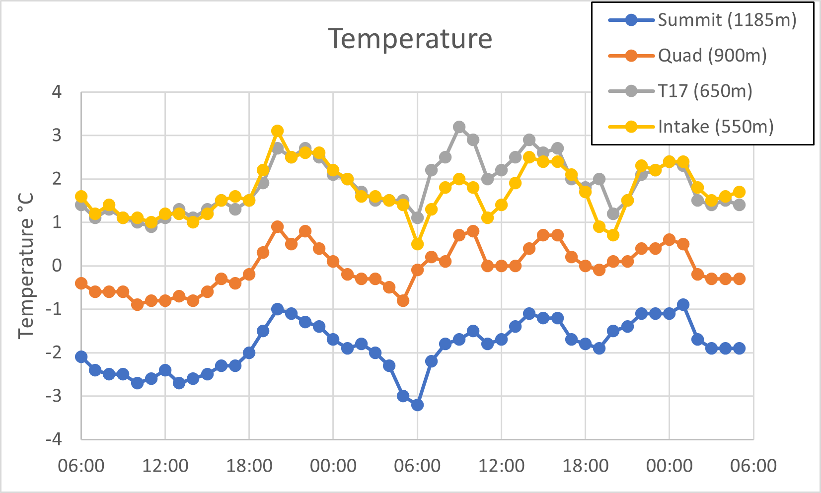
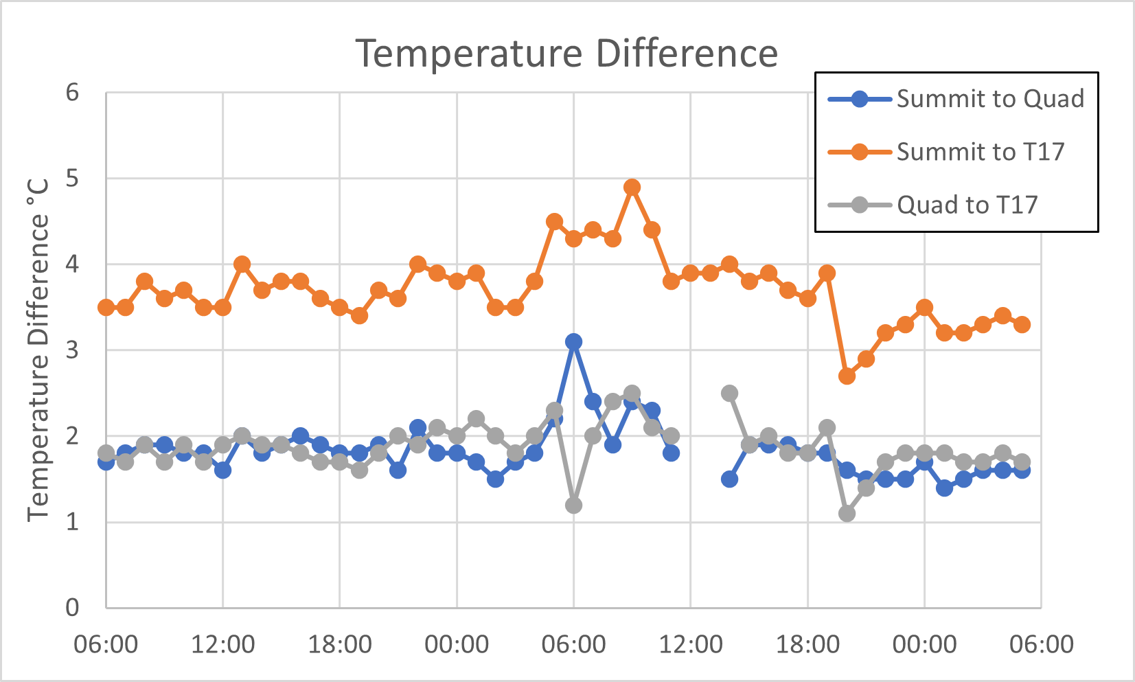
Concentrating on the stations on the front of the hill, the temperature differences between various stations can be calculated. For the same 48 hour period this is shown below. In terms of altitude the quad is almost equ-distant between the two other stations; 250 meters above T17, and 285 metres below the summit. Therefore it is not surprising that the T17/Quad temperature difference is similar to the Quad/Summit temperature difference.
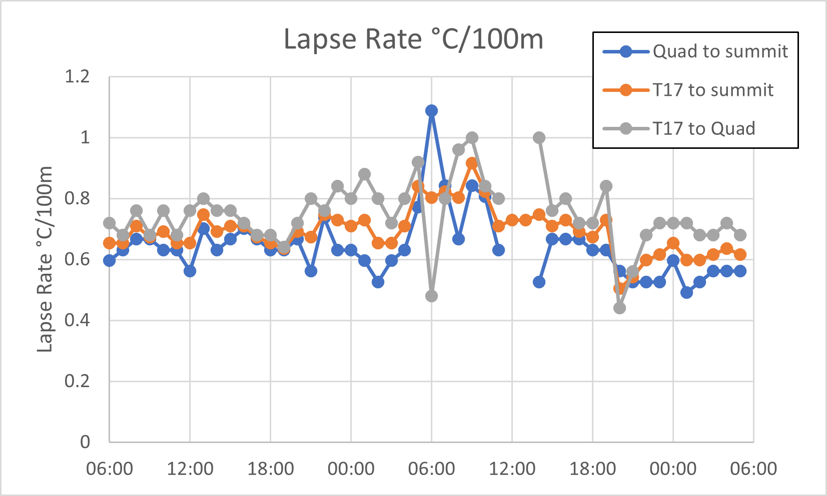
The lapse rate (rate of change in temperature with height) can then be be calculated for this period, and is shown below. The lapse rate for T17 to the Quad is slightly higher than from the Quad to the Summit. The reason for this may be that the air is more often saturated at this level (and this will reduce the lapse rate, more on this in a future post). It may also be due to slight inaccuracies in the stated heights of the weather stations (something I have not checked). However, averaging the T17 to Summit value over the 48 hours gives a value of 0.69 °C/100m or 1.06°C/500ft, very close to what Mark’s geography teacher told him.
Comments on this post
Got something to say? Leave a comment


Rob Ferguson
13th January 2023 5:51 pm
I wish such good high-level data had been available when I was trying to model snowmelt in the Cairngorms back in the 1980s! I had to extrapolate from the Braemar weather station. Fwiw lapse rates of 0.6-0.8 degC/100m seemed to work best.
lochaberadmin
14th January 2023 4:17 pm
The amount/quality of mountain weather data we have access to is great. The results of the this set of data of 0.69 degC/100m seems to fall right in the middle of the range you mention. Will be interesting to see if it changes when the air gets less humid.
Matt Dalby
13th January 2023 10:42 pm
Presumably the relative humidity since Wednesday morning has been fairly constant and fairly high hence the lapse rate hasn’t really changed. It’ll be interesting to see how the lapse rate changes next week if Northerly winds result in clearer weather and possibly slightly drier air in between the showers. In theory it should start to increase, at least until Thursday(ish) when it looks like milder damper air returns.
lochaberadmin
14th January 2023 4:14 pm
Good point, will try and have a look at that.